Suffolk Law, Atlas Team Transform Complex Zoning Codes Into Searchable Maps
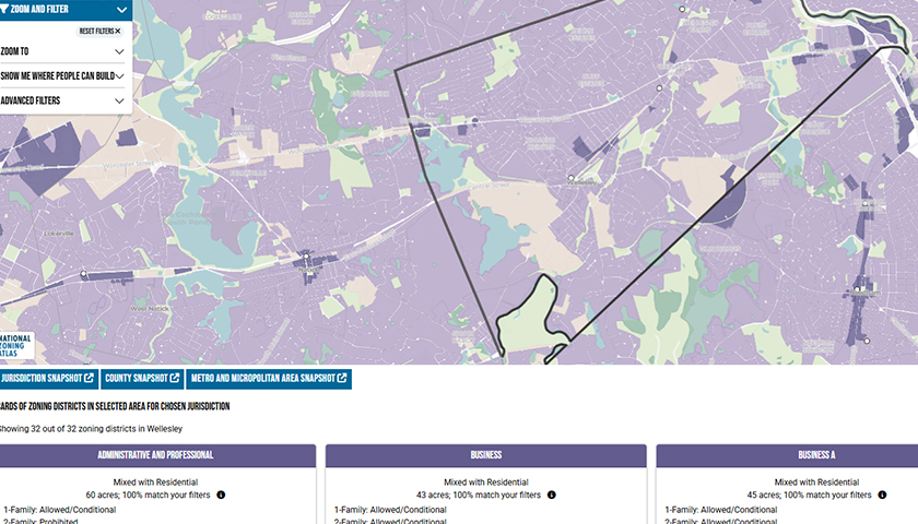
Massachusetts communities grappling with housing affordability now have a powerful new Google Maps-style tool to understand how local zoning regulations shape housing options. The Massachusetts Zoning Atlas compiles data for over 5,500 zoning districts into a publicly available tool that enables apples-to-apples comparisons of zoning codes across the state.
To start the project, land use law expert Professor John Infranca hired more than a dozen Suffolk Law students to help systematically code over 100 regulations for every zoning district in Massachusetts. They worked alongside National Zoning Atlas analysts, external volunteers, and consulting teams to decipher lengthy municipal codes—often riddled with conflicting provisions, multiple zoning overlays, and obsolete maps. Some codes were so complex that the team had to contact town officials to understand what their zoning actually permitted. As a result of the effort, Atlas users can see where different types of housing are allowed, what review processes are required, and over 100 specific regulations, such as height limits and parking requirements.
The project's findings have already drawn significant attention. The Boston Globe reported On July 17, 2025, that the Atlas reveals "apartment buildings with four units or more can only be built, under current local zoning rules, on roughly 4 percent of the land in this state," calling it "perhaps the most comprehensive look at the land-use policies of all 351 Massachusetts municipalities."
"The Atlas provides a vivid representation of how much of Massachusetts—even in areas near public transportation—is zoned exclusively for single-family housing, with large minimum lot sizes," Infranca says.
The Atlas will be unveiled at a launch event on Friday, July 18, 2025, at noon in the Law School's Blue Sky Lounge, featuring Infranca alongside Sara Bronin, founder and president of the National Zoning Atlas, with remarks from Abundant Housing Massachusetts Executive Director Jesse Kanson-Benanav and Lily Linke, Director of Municipal Engagement for the Citizen’s Housing and Planning Association.
Infranca is a co-editor of the Elgar Research Agenda for Land Use and Planning Law and the Cambridge Handbook of the Law of the Sharing Economy. Bronin, a law professor at George Washington University, is the author of "Key to the City: How Zoning Shapes Our World" (W.W. Norton).
The Zoning Information Gap
Efforts to confront the nation's affordable housing crisis have been hampered by a fundamental information gap: zoning regulations that determine what can be built where have remained largely opaque and difficult to compare across jurisdictions. "There are multiple zoning elements that affect the kind of housing that can go on a lot," Infranca explains. "They include parking constraints, maximum building height and lot coverage, floor-to-area ratios, and occupancy limitations. There's no simple way to look at all that zoning data in one place and to easily see trends across cities, states, or regions, and that makes government planning and practical solutions around affordability a challenge."
The Massachusetts Atlas reveals that 96% of residentially zoned land in the state allows single-family housing as of right, meaning no special permits or approvals are required, while just 4% allows multi-family housing as of right. Additionally, 78% of the land in the state that allows single-family housing requires minimum lot sizes of around one acre or more. These 1-acre mandates prevent the building of less expensive, smaller, denser housing, Infranca argues.
Professor Bronin's National Zoning Atlas began with a Connecticut Zoning Atlas. Following its successful launch, she looked to develop a nationwide Atlas. In 2022, she invited Infranca to assist with the Massachusetts effort. With Mercatus Center and Massachusetts Association of Realtors funding, Infranca hired the Suffolk Law students and recent graduates to pore over the regulations.
At the July 18 launch event, attendees will see demonstrations of how the Atlas can be used to analyze zoning patterns and learn how they can use the tool to inform debates over zoning statewide and in individual cities and towns.